

GIS digital agriculture management platform
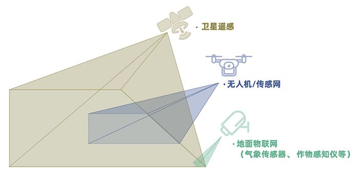
"Sky land integration" refers to relying on Beidou navigation technology, high-resolution satellite remote sensing technology, Internet of things, cloud computing and other new generation information technologies to provide real-time, dynamic and three-dimensional geographic information, positioning data and other agricultural fine services for UAV groups operating in the air and large unmanned agricultural machines on the ground, so as to create a platform for resource sharing Data integration and safety supervision platform to improve agricultural production, operation efficiency and agricultural product quality.
Product features
- Massive multi-source spatial information database: Integrating high score series, Landsat series and obit satellite data, Airborne Multispectral, hyperspectral, infrared and lidar data, the data is updated in time, and the maximum update frequency reaches 1 hour. It has an industry-level spatial information database.
- Big data products with complete functions: Provide targeted spatial information solutions for agriculture, forestry, marine, ecology, transportation and land planning.
- AI + precise algorithm of spatial information: Based on machine learning and deep learning, the platform has accurate spectral information inversion algorithm and image recognition algorithm to provide data results in a timely, intelligent and accurate manner.
Contact Us
Address : No. 618, Heping Road, Furong District, Changsha City, Hunan Province
Telephone : +86-731-88849090
E-mail : huazhi@higentec.com
Copyright©2025 Higentec Co., Ltd All rights reserved. This website supports IPv6 and IPv4 two-way access . Powered by www.300.cn ChangSha Business License SEO Tags